
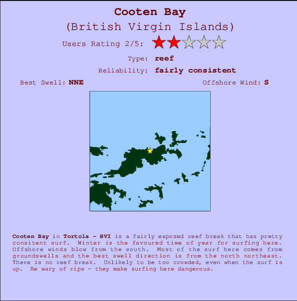
Cooten Bay Surf Guide
Cooten Bay in Tortola is a quite exposed beach break that has pretty consitent surf. Winter is the best time of year for surfing here. The best wind direction is from the south. Waves just as likely from local windswells as from distant groundswells and the best swell direction is from the north northeast. The beach break provides left and right handers. Rarely crowded here. Watch out for dangerous rips.
Cooten Bay Spot Info
| Type: | Rating: | Reliability: | Todays Sea Temp*: |
|---|---|---|---|
| fairly consistent | 28.4°C*ocean temperature recorded from satellite |
Surfing Cooten Bay:
The best conditions reported for surf at Cooten Bay occur when a North-northeast swell combines with an offshore wind direction from the South.

Previsão da Energia de Ondas (Força): 12hrs


Cooten Bay Surf:
Tuesday, 14 July 2026, 20:06 Local time| Terça-feira 14 | Quar | |||
| 5PM | 8PM | 11PM | 2AM | |
| Wave (m) | ||||
| Período (s) | 8 | 10 | 10 | 10 |
| Vento (km/h) | ||||
| Estado do Vento | cross | cross | cross | cross |
- /breaks/Cooten-Bay/forecasts/latest
Cooten Bay Surf Guide
Cooten Bay in Tortola is a quite exposed beach break that has pretty consitent surf. Winter is the best time of year for surfing here. The best wind direction is from the south. Waves just as likely from local windswells as from distant groundswells and the best swell direction is from the north northeast. The beach break provides left and right handers. Rarely crowded here. Watch out for dangerous rips.
Cooten Bay Spot Info
Type: Rating: Reliability: Todays Sea Temp*:  Reef
Reef 2
2fairly consistent 28.4°C*ocean temperature recorded from satelliteSurfing Cooten Bay:
The best conditions reported for surf at Cooten Bay occur when a North-northeast swell combines with an offshore wind direction from the South.
Previsão da Energia de Ondas (Força): 12hrs
Use a aba navegação acima para ver temperatura do mar em Cooten Bay, fotografias de Cooten Bay, previsões detalhadas do swell em Cooten Bay, previsões do vento e do tempo, webcams em Cooten Bay , vento atual em Tortola com base em dados ao vivo fornecidos por estações de meteorologia e previsões da maré em Cooten Bay. O link para os mapas do swell em British Virgin Islands abrirá uma imagem ampliada monstrando British Virgin Islands e os mares próximos. Estes mapas do swell podem ser animados para mostrar diferentes componentes do swell, energia das ondas, período das ondas, altura das ondas, assim como previsões do vento e do tempo, observações em tempo real do estado do tempo e do mar graças às bóias de British Virgin Islands, navios passantes e estações de meteorologia presentes na costa. Cada uma das páginas de previsão para este surf break apresenta as ferramentas do buscador global e regional para localizar as melores condições de surf na área ao redor de Cooten Bay.
Cooten Bay Surf:
Tuesday, 14 July 2026, 20:06 Local timeTerça-feira 14 Quar 5PM 8PM 11PM 2AM Wave (m) Período (s) 8 10 10 10 Vento (km/h) Estado do Vento cross cross cross cross - /breaks/Cooten-Bay/forecasts/latest
- /breaks/Cooten-Bay/forecasts/latest/six_day
Cooten Bay Surf Guide
Cooten Bay in Tortola is a quite exposed beach break that has pretty consitent surf. Winter is the best time of year for surfing here. The best wind direction is from the south. Waves just as likely from local windswells as from distant groundswells and the best swell direction is from the north northeast. The beach break provides left and right handers. Rarely crowded here. Watch out for dangerous rips.
Cooten Bay Spot Info
Type: Rating: Reliability: Todays Sea Temp*: Reef2fairly consistent 28.4°C*ocean temperature recorded from satelliteSurfing Cooten Bay:
The best conditions reported for surf at Cooten Bay occur when a North-northeast swell combines with an offshore wind direction from the South.
Previsão da Energia de Ondas (Força): 12hrs
Use a aba navegação acima para ver temperatura do mar em Cooten Bay, fotografias de Cooten Bay, previsões detalhadas do swell em Cooten Bay, previsões do vento e do tempo, webcams em Cooten Bay , vento atual em Tortola com base em dados ao vivo fornecidos por estações de meteorologia e previsões da maré em Cooten Bay. O link para os mapas do swell em British Virgin Islands abrirá uma imagem ampliada monstrando British Virgin Islands e os mares próximos. Estes mapas do swell podem ser animados para mostrar diferentes componentes do swell, energia das ondas, período das ondas, altura das ondas, assim como previsões do vento e do tempo, observações em tempo real do estado do tempo e do mar graças às bóias de British Virgin Islands, navios passantes e estações de meteorologia presentes na costa. Cada uma das páginas de previsão para este surf break apresenta as ferramentas do buscador global e regional para localizar as melores condições de surf na área ao redor de Cooten Bay.
Cooten Bay Surf:
Tuesday, 14 July 2026, 20:06 Local timeTerça-feira 14 Quar 5PM 8PM 11PM 2AM Wave (m) Período (s) 8 10 10 10 Vento (km/h) Estado do Vento cross cross cross cross - /breaks/Cooten-Bay/forecasts/latest
Cooten Bay Surf Guide
Cooten Bay in Tortola is a quite exposed beach break that has pretty consitent surf. Winter is the best time of year for surfing here. The best wind direction is from the south. Waves just as likely from local windswells as from distant groundswells and the best swell direction is from the north northeast. The beach break provides left and right handers. Rarely crowded here. Watch out for dangerous rips.
Cooten Bay Spot Info
Type: Rating: Reliability: Todays Sea Temp*: Reef2fairly consistent 28.4°C*ocean temperature recorded from satelliteSurfing Cooten Bay:
The best conditions reported for surf at Cooten Bay occur when a North-northeast swell combines with an offshore wind direction from the South.
Previsão da Energia de Ondas (Força): 12hrs
Use a aba navegação acima para ver temperatura do mar em Cooten Bay, fotografias de Cooten Bay, previsões detalhadas do swell em Cooten Bay, previsões do vento e do tempo, webcams em Cooten Bay , vento atual em Tortola com base em dados ao vivo fornecidos por estações de meteorologia e previsões da maré em Cooten Bay. O link para os mapas do swell em British Virgin Islands abrirá uma imagem ampliada monstrando British Virgin Islands e os mares próximos. Estes mapas do swell podem ser animados para mostrar diferentes componentes do swell, energia das ondas, período das ondas, altura das ondas, assim como previsões do vento e do tempo, observações em tempo real do estado do tempo e do mar graças às bóias de British Virgin Islands, navios passantes e estações de meteorologia presentes na costa. Cada uma das páginas de previsão para este surf break apresenta as ferramentas do buscador global e regional para localizar as melores condições de surf na área ao redor de Cooten Bay.
Cooten Bay Surf:
Tuesday, 14 July 2026, 20:06 Local timeTerça-feira 14 Quar 5PM 8PM 11PM 2AM Wave (m) Período (s) 8 10 10 10 Vento (km/h) Estado do Vento cross cross cross cross Tide Times:
Para Road Town %{dist} %{km} de %{location}
A PRÓXIMA É ÀS (hora local) faltam maré alta maré baixa Cooten Bay Tide Times and Tide Chart
Live Weather:
At Beef Island/Roadtown Airport, 9 km from Cooten Bay.
light winds from the NE
(km/h)Air temperature
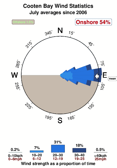
30°COverall Cooten Bay Surf Consistency and Wind Distribution in Julho
fotos da galeria
Contornos: Estradas & Rios: Escolha um spot de surf da lista 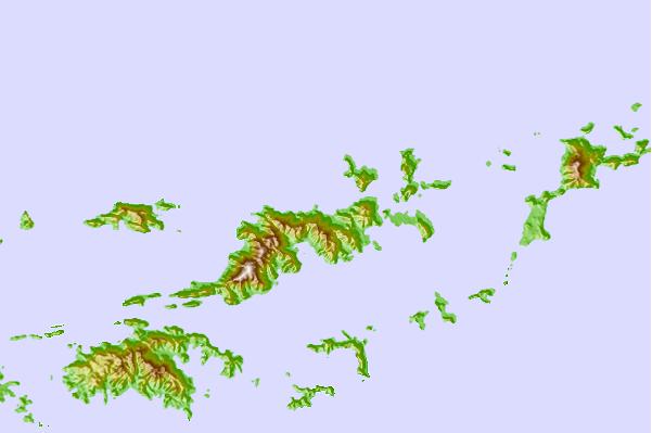
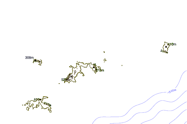
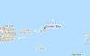
Use este mapa de relevo para navegar até Tortola surf quebras e estações que estão na área de maré Cooten Bay
Outros Spots de Surf mais próximos de Cooten Bay:
(Clique no nome do local para maiores detalhes)- Closest spot1 mi
- Second closest spot1 mi
- Third closest spot1 mi
- Fourth closest spot1 mi
- Fifth closest spot2 mi
Bóias ondográficas mais próxima de Cooten Bay:
- Closest bóia ondográfica17 mi
- Second closest bóia ondográfica58 mi
- Third closest bóia ondográfica99 mi
- Fourth closest bóia ondográfica133 mi
- Fifth closest bóia ondográfica153 mi
Estações de maré mais próximo de Cooten Bay:
- Closest estação de maréRoad Town4 mi
- Second closest estação de maréCoral Harbor, Saint Johns Island11 mi
- Third closest estação de maréLameshur Bay, Saint Johns12 mi
- Fourth closest estação de maréRedhook Bay, Saint Thomas Island19 mi
- Fifth closest estação de maréBenner Bay, Saint Thomas20 mi
Airports
- The closest passenger airport to Cooten Bay is Terrance B Lettsome International (Roadtown/beef Island) Airport (EIS) in Virgin Isl., 6 km (4 miles) away (directly).
- The second nearest airport to Cooten Bay is Cyril E King (St. Thomas) Airport (STT), also in Virgin Isl., 42 km (26 miles) away.
- Third is Henry E Rohlsen (St. Criox Island) Airport (STX) in Virgin Isl., 86 km (53 miles) away.
- Diego Jimenez Torres (Fajardo) Airport (FAJ) in Puerto Rico is 113 km (70 miles) away.
- Roosevelt Roads Ns Airport (NRR), also in Puerto Rico is the fifth nearest airport to Cooten Bay and is 113 km (70 miles) away.
- /breaks/Cooten-Bay/forecasts/latest


 Nearest