
Previsão:

Previsão de curto prazoprincipalmente seco. Very mild (máx. 18°C na Sexta de manhã, mín 11°C na Quarta à noite). o vento será geralmente fraco. | ||||||||||||||||||||||
Quarta-feira 29 | Quinta-feira 30 | Sexta-feira 31 | ||||||||||||||||||||
8 AM | 11 AM | 2 PM | 5 PM | 8 PM | 11 PM | 2 AM | 5 AM | 8 AM | 11 AM | 2 PM | 5 PM | 8 PM | 11 PM | 2 AM | 5 AM | 8 AM | 11 AM | 2 PM | 5 PM | 8 PM | 11 PM | |
Mapa da altura do Swell |  |  |  | 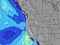 |  |  |  | 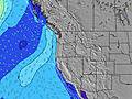 | ||||||||||||||
Swell Altura (m) Direção Período (s) | SW 17 | SW 17 | WNW 9 | WNW 9 | WNW 9 | WNW 8 | SW 16 | SW 16 | SW 16 | SW 16 | SW 16 | SW 16 | SW 16 | SW 16 | SW 15 | SW 15 | WNW 9 | WNW 9 | WNW 9 | WNW 9 | WNW 8 | WNW 8 |
Onda Gráfico | ||||||||||||||||||||||
290 | 280 | 238 | 211 | 197 | 188 | 163 | 161 | 159 | 157 | 155 | 155 | 155 | 153 | 147 | 107 | 124 | 121 | 108 | 106 | 125 | 122 | |
Vento (km/h) | ||||||||||||||||||||||
Estado do Vento maral cruzado-maral Cruzado cruzado-terral terral cristalino | cross-on | cross-on | cross-on | cross-on | cross-on | cross | cross | cross-off | cross | cross-on | on | cross-on | cross-on | cross-on | cross | cross-off | cross | cross-on | cross-on | cross-on | cross-on | glassy |
Maré Alta | 1:48PM1.92m | 00:46AM2.36m | 2:17PM1.99m | 1:24AM2.32m | 2:45PM2.06m | |||||||||||||||||
Maré Baixa | 7:10AM-0.20m | 6:57PM0.93m | 7:41AM-0.20m | 7:36PM0.86m | 8:11AM-0.15m | 8:16PM0.77m | ||||||||||||||||
6:03 | — | — | — | — | — | — | 6:03 | — | — | — | — | — | — | — | 6:05 | — | — | — | — | — | — | |
— | — | — | — | 8:43 | — | — | — | — | — | — | — | 8:42 | — | — | — | — | — | — | — | 8:40 | — | |
mm | — | — | — | — | — | — | — | — | — | — | — | — | — | — | — | — | — | — | — | — | — | — |
Temp. °C | 14 | 15 | 15 | 15 | 14 | 13 | 12 | 11 | 11 | 15 | 16 | 16 | 15 | 14 | 13 | 13 | 13 | 18 | 17 | 17 | 16 | 15 |
Ressent. °C | 12 | 13 | 12 | 12 | 12 | 13 | 11 | 10 | 10 | 13 | 12 | 13 | 13 | 12 | 12 | 11 | 10 | 15 | 13 | 14 | 15 | 15 |
Swell 1 Altura (m) Direção Período (s) | WNW 9 | WNW 9 | WNW 9 | WNW 9 | WNW 9 | WNW 8 | WNW 8 | WNW 8 | WNW 8 | WNW 8 | WNW 8 | WNW 8 | WNW 8 | WNW 8 | WNW 8 | WNW 9 | WNW 9 | WNW 9 | WNW 9 | WNW 9 | WNW 8 | WNW 8 |
227 | 238 | 238 | 172 | 197 | 188 | 143 | 140 | 117 | 105 | 84 | 75 | 58 | 58 | 76 | 99 | 124 | 121 | 108 | 106 | 125 | 122 | |
Swell 2 Altura (m) Direção Período (s) | SW 17 | SW 17 | SW 16 | SW 16 | SW 16 | SW 16 | SW 16 | SW 16 | SW 16 | SW 16 | SW 16 | SW 16 | SW 16 | SW 16 | SW 15 | SW 15 | SW 15 | SW 15 | SW 14 | SW 14 | SW 14 | SW 14 |
290 | 280 | 214 | 211 | 163 | 163 | 163 | 161 | 159 | 157 | 155 | 155 | 155 | 153 | 147 | 107 | 104 | 75 | 74 | 74 | 73 | 73 | |
Swell 3 Altura (m) Direção Período (s) | — | — | SSW 11 | SSW 11 | SSW 11 | SSW 11 | SSW 11 | SSW 10 | SW 11 | SW 11 | SW 11 | SW 11 | — | — | NNW 4 | NNW 4 | — | — | S 8 | S 8 | — | NNW 4 |
— | — | 12 | 12 | 12 | 12 | 11 | 11 | 4 | 5 | 5 | 5 | — | — | 2 | 2 | — | — | 1 | 1 | — | 5 | |
Ondas de vento Altura (m) Direção Período (s) | — | — | — | NNW 4 | — | — | — | — | — | — | NNW 3 | NNW 4 | N 4 | NNW 4 | — | — | — | — | NNW 3 | NNW 4 | NNW 4 | — |
— | — | — | 15 | — | — | — | — | — | — | 3 | 7 | 7 | 4 | — | — | — | — | 6 | 11 | 8 | — | |
Terral ou glassy mais perto | ||||||||||||||||||||||
Distância (km) | 157 | 400 | 738 | 737 | 737 | 29 | 29 | 0 | 29 | 175 | 559 | 651 | 179 | 157 | 3 | 0 | 29 | 537 | 175 | 637 | 270 | 0 |
Melhor previsões de ondas em South Oregon | ||||||||||||||||||||||
Melhor previsões de ondas em United States | ||||||||||||||||||||||
Buscador de Ondas Global | ||||||||||||||||||||||
- Map Icons:
 Break
Break Live Wave Height (m)
 Live Wind Speed (km/h)
 Surf Rating (10 Max)
 Ocean Swells (m)
- Wind Speed (km/h)
widget de graça do Surf-Forecast.com para o seu site
O relatório de surf / widget do tempo abaixo está disponível para incorporar em sites de terceiros gratuitamente e fornece um resumo das nossas Coos Bay Bastendorf Beach surf tempo. Simplesmente pegar o trecho de código html que fornecemos e colá-lo em seu próprio site. Você pode escolher seu idioma preferido e unidades métrico/imperial para o surf tempo de alimentação para atender aos usuários do seu site.... Clique aqui para adquirir o código.
 Nearest