
Previsão:

Previsão de curto prazoprincipalmente seco. Warm (máx. 26°C na Terça de manhã, mín 24°C no Domingo à noite). Ventos aumentam (vento fraco de Este-Sudeste no Domingo à noite, ventos frescos de Nordeste na Seg à noite). | |||||||||||||||||||
Dom 2 | Segunda-feira 3 | Terça-feira 4 | |||||||||||||||||
5 PM | 8 PM | 11 PM | 2 AM | 5 AM | 8 AM | 11 AM | 2 PM | 5 PM | 8 PM | 11 PM | 2 AM | 5 AM | 8 AM | 11 AM | 2 PM | 5 PM | 8 PM | 11 PM | |
Mapa da altura do Swell |  |  |  |  |  | 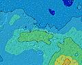 |  | ||||||||||||
Swell Altura (m) Direção Período (s) | SSW 14 | SSW 14 | E 8 | E 8 | ENE 8 | ENE 8 | ENE 8 | ENE 8 | ENE 7 | ENE 7 | ENE 4 | ENE 4 | NE 5 | ENE 7 | ENE 7 | ENE 8 | ENE 8 | ENE 8 | ENE 8 |
Onda Gráfico | |||||||||||||||||||
0 | 0 | 42 | 42 | 45 | 45 | 45 | 44 | 57 | 52 | 25 | 35 | 33 | 86 | 86 | 85 | 104 | 101 | 99 | |
Vento (km/h) | |||||||||||||||||||
Estado do Vento maral cruzado-maral Cruzado cruzado-terral terral cristalino | cross-off | cross-off | cross | cross-on | cross | cross-on | cross-on | cross-on | cross-on | cross-on | cross-on | cross-on | cross-on | cross-on | cross-on | cross-on | cross-on | cross-on | cross |
Maré Alta | 2:11AM0.26m | 2:38PM0.26m | 2:25AM0.25m | 2:59PM0.23m | |||||||||||||||
Maré Baixa | 8:27PM0.07m | 8:31AM0.04m | 8:45PM0.09m | 8:54AM0.06m | 8:56PM0.11m | ||||||||||||||
— | — | — | — | 6:24 | — | — | — | — | — | — | — | 6:24 | — | — | — | — | — | — | |
5:45 | — | — | — | — | — | — | — | 5:45 | — | — | — | — | — | — | — | 5:45 | — | — | |
mm | — | — | — | — | — | — | — | — | — | — | — | — | — | — | — | — | — | — | — |
Temp. °C | 24 | 25 | 25 | 24 | 24 | 24 | 24 | 25 | 25 | 25 | 25 | 25 | 25 | 26 | 25 | 26 | 26 | 25 | 26 |
Ressent. °C | 26 | 27 | 26 | 22 | 23 | 23 | 23 | 25 | 24 | 25 | 24 | 23 | 25 | 26 | 26 | 28 | 29 | 27 | 28 |
Swell 1 Altura (m) Direção Período (s) | SSW 14 | SSW 14 | SSW 14 | SSW 14 | SSW 13 | SSW 13 | SSW 13 | S 14 | SSW 14 | SSW 14 | SSW 13 | SSW 13 | SSW 13 | SSW 13 | ENE 7 | SSW 14 | SSW 14 | SSW 14 | SSW 14 |
602 | 585 | 815 | 646 | 515 | 437 | 444 | 334 | 232 | 246 | 312 | 222 | 222 | 273 | 86 | 437 | 647 | 701 | 530 | |
Swell 2 Altura (m) Direção Período (s) | S 10 | S 10 | S 18 | S 17 | S 16 | S 16 | S 16 | SSW 13 | S 14 | S 13 | S 13 | S 13 | S 12 | SSW 16 | SSW 13 | ENE 8 | ENE 8 | ENE 8 | ENE 8 |
117 | 115 | 294 | 284 | 330 | 242 | 170 | 222 | 260 | 170 | 31 | 119 | 105 | 104 | 219 | 85 | 104 | 101 | 99 | |
Swell 3 Altura (m) Direção Período (s) | S 18 | S 18 | N 9 | N 9 | N 9 | NNE 9 | N 9 | NNE 9 | NNE 9 | N 9 | NNE 9 | E 8 | E 8 | S 12 | SSW 16 | S 12 | NE 12 | SW 23 | SW 21 |
234 | 304 | 15 | 15 | 15 | 16 | 6 | 16 | 16 | 6 | 7 | 10 | 18 | 25 | 171 | 11 | 23 | 83 | 117 | |
Ondas de vento Altura (m) Direção Período (s) | — | ESE 2 | E 8 | E 8 | ENE 8 | ENE 8 | ENE 8 | ENE 8 | ENE 7 | ENE 7 | ENE 4 | ENE 4 | NE 5 | ENE 7 | NNE 4 | NNE 4 | — | — | — |
— | 1 | 42 | 42 | 45 | 45 | 45 | 44 | 57 | 52 | 25 | 35 | 33 | 86 | 7 | 7 | — | — | — | |
Terral ou glassy mais perto | |||||||||||||||||||
Distância (km) | 7 | 7 | 12 | 39 | 39 | 12 | 12 | 12 | 12 | 12 | 192 | 193 | 12 | 12 | 12 | 12 | 12 | 12 | 12 |
Melhor previsões de ondas em Moorea | |||||||||||||||||||
Melhor previsões de ondas em French Polynesia | |||||||||||||||||||
Buscador de Ondas Global | |||||||||||||||||||
- Map Icons:
 Break
Break Live Wave Height (m)
 Live Wind Speed (km/h)
 Surf Rating (10 Max)
 Ocean Swells (m)
- Wind Speed (km/h)
widget de graça do Surf-Forecast.com para o seu site
O relatório de surf / widget do tempo abaixo está disponível para incorporar em sites de terceiros gratuitamente e fornece um resumo das nossas Cook Bay surf tempo. Simplesmente pegar o trecho de código html que fornecemos e colá-lo em seu próprio site. Você pode escolher seu idioma preferido e unidades métrico/imperial para o surf tempo de alimentação para atender aos usuários do seu site.... Clique aqui para adquirir o código.
 Nearest