
Previsão:

Previsão de curto prazochuviscos (total 4mm), principalmente caindo na Terça à noite. Very mild (máx. 17°C na Quarta à tarde, mín 12°C na Quarta à noite). o vento será geralmente fraco. | ||||||||||||||||||||||||
Quarta-feira 29 | Quinta-feira 30 | Sexta-feira 31 | ||||||||||||||||||||||
1 AM | 4 AM | 7 AM | 10 AM | 1 PM | 4 PM | 7 PM | 10 PM | 1 AM | 4 AM | 7 AM | 10 AM | 1 PM | 4 PM | 7 PM | 10 PM | 1 AM | 4 AM | 7 AM | 10 AM | 1 PM | 4 PM | 7 PM | 10 PM | |
Mapa da altura do Swell |  | 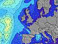 |  |  |  |  |  |  |  | |||||||||||||||
Swell Altura (m) Direção Período (s) | W 8 | W 8 | W 8 | WNW 8 | WNW 8 | W 8 | W 8 | W 7 | N 9 | W 8 | WNW 8 | N 9 | N 9 | N 9 | N 8 | N 8 | N 8 | W 6 | W 6 | W 6 | W 6 | W 6 | W 6 | W 6 |
Onda Gráfico | ||||||||||||||||||||||||
339 | 260 | 257 | 257 | 218 | 172 | 196 | 159 | 168 | 181 | 226 | 230 | 225 | 220 | 167 | 132 | 104 | 128 | 113 | 113 | 95 | 95 | 97 | 81 | |
Vento (km/h) | ||||||||||||||||||||||||
Estado do Vento maral cruzado-maral Cruzado cruzado-terral terral cristalino | cross-off | cross-off | cross-off | cross-off | cross | cross | cross | cross-off | cross-off | cross-off | cross-on | cross-on | cross | cross | cross | cross-off | cross-off | cross-off | cross-off | cross-off | cross-off | cross | cross | cross |
Maré Alta | 6:32AM2.79m | 6:51PM3.28m | 7:05AM2.86m | 7:23PM3.40m | 7:38AM2.91m | 7:55PM3.46m | ||||||||||||||||||
Maré Baixa | 00:28AM0.59m | 12:25PM0.48m | 1:03AM0.47m | 12:58PM0.38m | 1:35AM0.39m | 1:29PM0.33m | ||||||||||||||||||
— | 5:43 | — | — | — | — | — | — | — | 5:45 | — | — | — | — | — | — | — | 5:46 | — | — | — | — | — | — | |
— | — | — | — | — | — | 9:43 | — | — | — | — | — | — | — | 9:40 | — | — | — | — | — | — | — | 9:38 | — | |
mm | — | — | 2 | 1 | 1 | — | — | — | — | — | — | — | — | — | — | — | — | — | — | — | — | — | — | — |
Temp. °C | 15 | 14 | 13 | 14 | 16 | 17 | 16 | 13 | 12 | 12 | 13 | 14 | 15 | 15 | 15 | 13 | 12 | 12 | 12 | 14 | 16 | 16 | 15 | 13 |
Ressent. °C | 15 | 13 | 12 | 13 | 14 | 13 | 13 | 11 | 10 | 10 | 9 | 9 | 10 | 10 | 11 | 10 | 9 | 9 | 9 | 10 | 11 | 11 | 11 | 11 |
Swell 1 Altura (m) Direção Período (s) | W 8 | W 8 | W 8 | WNW 8 | WNW 8 | W 8 | NNW 11 | W 7 | N 9 | N 9 | N 9 | N 9 | N 9 | N 9 | N 8 | N 8 | N 8 | N 8 | N 8 | N 8 | N 8 | N 8 | N 8 | N 8 |
339 | 260 | 257 | 257 | 218 | 172 | 37 | 159 | 168 | 164 | 198 | 230 | 225 | 220 | 167 | 132 | 104 | 80 | 76 | 58 | 63 | 65 | 63 | 63 | |
Swell 2 Altura (m) Direção Período (s) | N 9 | N 9 | N 9 | N 9 | N 9 | N 9 | N 9 | N 9 | — | — | — | — | — | — | — | — | — | — | W 12 | W 12 | W 11 | WSW 11 | WSW 11 | WSW 10 |
80 | 80 | 81 | 60 | 58 | 40 | 24 | 110 | — | — | — | — | — | — | — | — | — | — | 3 | 3 | 2 | 12 | 11 | 10 | |
Swell 3 Altura (m) Direção Período (s) | — | — | — | — | — | N 11 | — | — | — | — | — | — | — | — | — | — | — | — | — | — | — | — | — | — |
— | — | — | — | — | 9 | — | — | — | — | — | — | — | — | — | — | — | — | — | — | — | — | — | — | |
Ondas de vento Altura (m) Direção Período (s) | — | — | — | — | — | — | W 8 | — | W 7 | W 8 | WNW 8 | WNW 7 | WNW 7 | W 7 | W 7 | W 6 | W 6 | W 6 | W 6 | W 6 | W 6 | W 6 | W 6 | W 6 |
— | — | — | — | — | — | 196 | — | 134 | 181 | 226 | 199 | 160 | 120 | 107 | 98 | 98 | 128 | 113 | 113 | 95 | 95 | 97 | 81 | |
Terral ou glassy mais perto | ||||||||||||||||||||||||
Distância (km) | 0 | 0 | 0 | 0 | 9 | 179 | 155 | 0 | 0 | 0 | 135 | 555 | 579 | 611 | 155 | 0 | 0 | 0 | 0 | 9 | 233 | 2186 | 1735 | 9 |
Melhor previsões de ondas em Mayo and Achill Island | ||||||||||||||||||||||||
Melhor previsões de ondas em Ireland | ||||||||||||||||||||||||
Buscador de Ondas Global | ||||||||||||||||||||||||
- Map Icons:
 Break
Break Live Wave Height (m)
 Live Wind Speed (km/h)
 Surf Rating (10 Max)
 Ocean Swells (m)
- Wind Speed (km/h)
widget de graça do Surf-Forecast.com para o seu site
O relatório de surf / widget do tempo abaixo está disponível para incorporar em sites de terceiros gratuitamente e fornece um resumo das nossas Bunatrahir Bay surf tempo. Simplesmente pegar o trecho de código html que fornecemos e colá-lo em seu próprio site. Você pode escolher seu idioma preferido e unidades métrico/imperial para o surf tempo de alimentação para atender aos usuários do seu site.... Clique aqui para adquirir o código.
 Nearest