
Previsão:

Previsão de curto prazochuva moderada (total 12mm), mais intensa na Quarta à tarde. Warm (máx. 29°C na Quarta de manhã, mín 28°C na Quarta à noite). o vento será geralmente fraco. | ||||||||||||||||||||||
Quarta-feira 29 | Quinta-feira 30 | Sexta-feira 31 | ||||||||||||||||||||
7 AM | 10 AM | 1 PM | 4 PM | 7 PM | 10 PM | 1 AM | 4 AM | 7 AM | 10 AM | 1 PM | 4 PM | 7 PM | 10 PM | 1 AM | 4 AM | 7 AM | 10 AM | 1 PM | 4 PM | 7 PM | 10 PM | |
Mapa da altura do Swell | 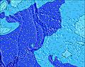 | 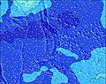 | 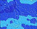 | 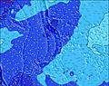 | 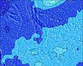 |  | 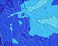 | 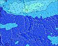 | ||||||||||||||
Swell Altura (m) Direção Período (s) | E 7 | E 7 | ENE 7 | E 7 | ENE 7 | ENE 9 | ENE 9 | ENE 9 | ENE 8 | ENE 8 | NNE 10 | ENE 8 | ENE 8 | ENE 8 | ENE 8 | ENE 8 | ENE 8 | E 15 | E 14 | E 16 | E 15 | E 14 |
Onda Gráfico | ||||||||||||||||||||||
127 | 103 | 79 | 57 | 48 | 33 | 33 | 79 | 75 | 73 | 33 | 54 | 53 | 51 | 51 | 51 | 50 | 69 | 91 | 243 | 510 | 598 | |
Vento (km/h) | ||||||||||||||||||||||
Estado do Vento maral cruzado-maral Cruzado cruzado-terral terral cristalino | cross-on | cross | cross | cross-off | cross | cross | cross | cross | cross | cross | cross-off | cross-off | off | glassy | glassy | glassy | glassy | glassy | glassy | glassy | off | cross-off |
Maré Alta | 5:13AM0.71m | 9:33PM0.69m | 6:00AM0.70m | 9:57PM0.70m | 6:48AM0.69m | |||||||||||||||||
Maré Baixa | 1:26PM0.08m | 1:40AM0.62m | 2:02PM0.09m | 2:28AM0.60m | 2:36PM0.13m | |||||||||||||||||
5:58 | — | — | — | — | — | — | 5:58 | — | — | — | — | — | — | — | 5:58 | — | — | — | — | — | — | |
— | — | — | 6:47 | — | — | — | — | — | — | — | 6:46 | — | — | — | — | — | — | — | 6:46 | — | — | |
mm | — | — | 2 | 4 | 1 | — | 2 | 3 | — | — | — | — | — | — | — | — | — | — | — | — | — | — |
Temp. °C | 29 | 29 | 29 | 29 | 29 | 29 | 29 | 29 | 28 | 29 | 29 | 29 | 29 | 28 | 28 | 28 | 28 | 28 | 29 | 29 | 29 | 29 |
Ressent. °C | 30 | 31 | 32 | 33 | 33 | 33 | 33 | 32 | 31 | 32 | 32 | 33 | 34 | 33 | 33 | 33 | 33 | 33 | 34 | 34 | 33 | 33 |
Swell 1 Altura (m) Direção Período (s) | SSE 7 | E 7 | ENE 7 | E 7 | ENE 7 | ENE 6 | ENE 6 | ENE 9 | ENE 8 | ENE 8 | ENE 6 | ENE 8 | ENE 8 | ENE 8 | ENE 8 | ENE 8 | ENE 8 | ENE 8 | ENE 8 | E 16 | E 15 | E 14 |
10 | 103 | 79 | 57 | 48 | 33 | 33 | 79 | 75 | 73 | 21 | 54 | 53 | 51 | 51 | 51 | 50 | 50 | 68 | 243 | 510 | 598 | |
Swell 2 Altura (m) Direção Período (s) | ENE 9 | NNE 10 | NNE 10 | ENE 9 | SSE 9 | SSE 9 | SE 9 | NNE 11 | NNE 10 | NNE 10 | NNE 10 | NNE 10 | NNE 10 | NNE 9 | NNE 9 | NNE 9 | NNE 9 | E 15 | E 14 | ENE 8 | ENE 8 | ENE 10 |
17 | 19 | 19 | 27 | 34 | 33 | 22 | 37 | 33 | 33 | 33 | 33 | 32 | 29 | 28 | 28 | 28 | 69 | 91 | 51 | 50 | 98 | |
Swell 3 Altura (m) Direção Período (s) | NNE 10 | SSE 7 | SSE 7 | NNE 11 | ENE 9 | ENE 9 | ENE 9 | SE 9 | SE 9 | SE 9 | ENE 8 | SE 9 | S 7 | S 7 | S 6 | SE 9 | E 15 | NNE 9 | NNE 9 | SSW 8 | SW 8 | SW 8 |
20 | 9 | 9 | 25 | 16 | 26 | 25 | 22 | 22 | 21 | 24 | 13 | 8 | 8 | 7 | 12 | 41 | 28 | 28 | 41 | 46 | 45 | |
Ondas de vento Altura (m) Direção Período (s) | E 7 | — | — | — | — | — | — | — | — | — | — | — | — | — | — | — | — | — | — | — | — | — |
127 | — | — | — | — | — | — | — | — | — | — | — | — | — | — | — | — | — | — | — | — | — | |
Terral ou glassy mais perto | ||||||||||||||||||||||
Distância (km) | 231 | 231 | 2219 | 0 | 239 | 2263 | 2259 | 2221 | 2227 | 2221 | 0 | 0 | 0 | 0 | 0 | 0 | 0 | 0 | 0 | 0 | 0 | 0 |
Melhor previsões de ondas em Saipan | ||||||||||||||||||||||
Melhor previsões de ondas em Northern Mariana Islands | ||||||||||||||||||||||
Buscador de Ondas Global | ||||||||||||||||||||||
- Map Icons:
 Break
Break Live Wave Height (m)
 Live Wind Speed (km/h)
 Surf Rating (10 Max)
 Ocean Swells (m)
- Wind Speed (km/h)
widget de graça do Surf-Forecast.com para o seu site
O relatório de surf / widget do tempo abaixo está disponível para incorporar em sites de terceiros gratuitamente e fornece um resumo das nossas Bird Island surf tempo. Simplesmente pegar o trecho de código html que fornecemos e colá-lo em seu próprio site. Você pode escolher seu idioma preferido e unidades métrico/imperial para o surf tempo de alimentação para atender aos usuários do seu site.... Clique aqui para adquirir o código.
 Nearest