
Previsão:

Previsão de curto prazochuva moderada (total 10mm), mais intensa na Terça à noite. Warm (máx. 28°C na Segunda de manhã, mín 27°C na Segunda de manhã). principalmente ventos frescos. | ||||||||||||||||||||||||
Segunda-feira 27 | Terça-feira 28 | Quarta-feira 29 | ||||||||||||||||||||||
2 AM | 5 AM | 8 AM | 11 AM | 2 PM | 5 PM | 8 PM | 11 PM | 2 AM | 5 AM | 8 AM | 11 AM | 2 PM | 5 PM | 8 PM | 11 PM | 2 AM | 5 AM | 8 AM | 11 AM | 2 PM | 5 PM | 8 PM | 11 PM | |
Mapa da altura do Swell |  |  |  |  |  |  |  | 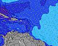 |  | |||||||||||||||
Swell Altura (m) Direção Período (s) | ENE 8 | E 8 | E 8 | E 8 | E 8 | E 8 | E 8 | E 8 | E 7 | E 6 | E 7 | E 7 | E 6 | E 7 | E 7 | E 7 | E 7 | E 8 | E 8 | E 8 | E 8 | E 8 | E 8 | E 8 |
Onda Gráfico | ||||||||||||||||||||||||
65 | 61 | 80 | 78 | 99 | 99 | 99 | 97 | 87 | 54 | 72 | 86 | 89 | 150 | 146 | 203 | 269 | 287 | 341 | 391 | 412 | 412 | 422 | 422 | |
Vento (km/h) | ||||||||||||||||||||||||
Estado do Vento maral cruzado-maral Cruzado cruzado-terral terral cristalino | cross-on | cross-on | cross-on | cross-on | cross-on | cross-on | cross-on | cross-on | cross-on | cross-on | cross-on | cross-on | cross-on | cross-on | cross-on | cross-on | cross-on | cross-on | cross-on | cross-on | cross-on | cross-on | cross-on | cross-on |
Maré Alta | 00:37AM0.37m | 5:45PM0.28m | 1:35AM0.38m | 5:51PM0.29m | 2:25AM0.39m | 5:59PM0.30m | ||||||||||||||||||
Maré Baixa | 9:13AM0.04m | 7:05PM0.28m | 9:48AM0.04m | 8:02PM0.28m | 10:21AM0.05m | 8:56PM0.28m | ||||||||||||||||||
— | 5:46 | — | — | — | — | — | — | — | 5:46 | — | — | — | — | — | — | — | 5:46 | — | — | — | — | — | — | |
— | — | — | — | — | 6:38 | — | — | — | — | — | — | — | 6:38 | — | — | — | — | — | — | — | 6:37 | — | — | |
mm | 1 | 1 | — | 1 | — | — | — | — | 1 | — | — | — | — | 1 | 1 | 1 | 2 | 2 | 1 | — | — | — | — | — |
Temp. °C | 27 | 27 | 27 | 28 | 28 | 28 | 27 | 27 | 27 | 27 | 27 | 28 | 28 | 27 | 27 | 27 | 27 | 27 | 27 | 28 | 28 | 27 | 27 | 27 |
Ressent. °C | 29 | 29 | 29 | 30 | 29 | 29 | 28 | 28 | 27 | 27 | 26 | 28 | 28 | 27 | 27 | 27 | 27 | 27 | 26 | 27 | 26 | 26 | 26 | 26 |
Swell 1 Altura (m) Direção Período (s) | ENE 8 | E 8 | SE 9 | SE 9 | SE 9 | SE 9 | SE 9 | SE 9 | SE 9 | SE 9 | SE 9 | SE 9 | SE 8 | ESE 8 | SE 8 | — | NE 10 | — | — | — | — | — | — | — |
65 | 61 | 21 | 21 | 21 | 21 | 21 | 21 | 20 | 20 | 20 | 19 | 18 | 7 | 18 | — | 4 | — | — | — | — | — | — | — | |
Swell 2 Altura (m) Direção Período (s) | SE 9 | SE 9 | — | — | — | — | — | — | — | — | — | — | — | NE 10 | — | — | — | — | — | — | — | — | — | — |
21 | 40 | — | — | — | — | — | — | — | — | — | — | — | 4 | — | — | — | — | — | — | — | — | — | — | |
Swell 3 Altura (m) Direção Período (s) | — | — | — | — | — | — | — | — | — | — | — | — | — | NE 10 | — | — | — | — | — | — | — | — | — | — |
— | — | — | — | — | — | — | — | — | — | — | — | — | 4 | — | — | — | — | — | — | — | — | — | — | |
Ondas de vento Altura (m) Direção Período (s) | ESE 9 | — | E 8 | E 8 | E 8 | E 8 | E 8 | E 8 | E 7 | E 6 | E 7 | E 7 | E 6 | E 7 | E 7 | E 7 | E 7 | E 8 | E 8 | E 8 | E 8 | E 8 | E 8 | E 8 |
54 | — | 80 | 78 | 99 | 99 | 99 | 97 | 87 | 54 | 72 | 86 | 89 | 150 | 146 | 203 | 269 | 287 | 341 | 391 | 412 | 412 | 422 | 422 | |
Terral ou glassy mais perto | ||||||||||||||||||||||||
Distância (km) | 133 | 53 | 133 | 134 | 249 | 49 | 427 | 396 | 537 | 537 | 547 | 543 | 1821 | 603 | 602 | 545 | 580 | 580 | 777 | 777 | 513 | 657 | 652 | 618 |
Melhor previsões de ondas em Guadeloupe - Grande Terre | ||||||||||||||||||||||||
Melhor previsões de ondas em Guadeloupe | ||||||||||||||||||||||||
Buscador de Ondas Global | ||||||||||||||||||||||||
- Map Icons:
 Break
Break Live Wave Height (m)
 Live Wind Speed (km/h)
 Surf Rating (10 Max)
 Ocean Swells (m)
- Wind Speed (km/h)
widget de graça do Surf-Forecast.com para o seu site
O relatório de surf / widget do tempo abaixo está disponível para incorporar em sites de terceiros gratuitamente e fornece um resumo das nossas Bananier surf tempo. Simplesmente pegar o trecho de código html que fornecemos e colá-lo em seu próprio site. Você pode escolher seu idioma preferido e unidades métrico/imperial para o surf tempo de alimentação para atender aos usuários do seu site.... Clique aqui para adquirir o código.
 Nearest