
Previsão:

Previsão de curto prazochuva moderada (total 11mm), mais intensa na Terça à tarde. Warm (máx. 32°C na Terça de manhã, mín 26°C na Terça à tarde). o vento será geralmente fraco. | |||||||||||||||||||
Seg 3 | Terça-feira 4 | Quarta-feira 5 | |||||||||||||||||
4 PM | 7 PM | 10 PM | 1 AM | 4 AM | 7 AM | 10 AM | 1 PM | 4 PM | 7 PM | 10 PM | 1 AM | 4 AM | 7 AM | 10 AM | 1 PM | 4 PM | 7 PM | 10 PM | |
Mapa da altura do Swell | 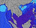 | 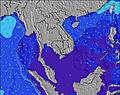 | 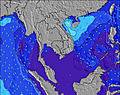 | 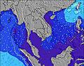 | 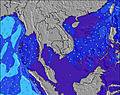 | 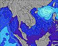 | 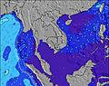 | ||||||||||||
Swell Altura (m) Direção Período (s) | E 16 | S 5 | S 5 | SSW 5 | E 18 | E 18 | E 18 | E 18 | SSW 6 | SSW 7 | E 15 | E 16 | E 16 | E 16 | E 16 | E 16 | E 20 | E 16 | E 20 |
Onda Gráfico | |||||||||||||||||||
5 | 0 | 0 | 0 | 6 | 6 | 6 | 6 | 0 | 0 | 4 | 5 | 5 | 5 | 5 | 5 | 8 | 5 | 7 | |
Vento (km/h) | |||||||||||||||||||
Estado do Vento maral cruzado-maral Cruzado cruzado-terral terral cristalino | cross | glassy | cross-off | cross-off | off | glassy | cross-on | cross-on | cross-on | off | glassy | cross-off | off | cross-off | cross | glassy | glassy | glassy | off |
Maré Alta | 1:57AM1.06m | 12:48PM1.09m | 2:03AM1.16m | 2:03PM0.91m | |||||||||||||||
Maré Baixa | 7:16PM0.50m | 7:12AM0.81m | 7:20PM0.63m | 8:43AM0.71m | 7:08PM0.73m | ||||||||||||||
— | — | — | — | 5:30 | — | — | — | — | — | — | — | 5:30 | — | — | — | — | — | — | |
6:07 | — | — | — | — | — | — | — | 6:07 | — | — | — | — | — | — | — | 6:07 | — | — | |
mm | — | 1 | — | — | 1 | — | — | — | 4 | 5 | — | — | — | — | — | — | — | — | — |
Temp. °C | 31 | 29 | 28 | 27 | 27 | 28 | 32 | 31 | 27 | 26 | 27 | 27 | 27 | 27 | 27 | 28 | 28 | 28 | 28 |
Ressent. °C | 35 | 34 | 32 | 31 | 31 | 32 | 36 | 33 | 31 | 29 | 32 | 31 | 30 | 31 | 31 | 32 | 32 | 32 | 31 |
Swell 1 Altura (m) Direção Período (s) | E 13 | S 5 | S 5 | S 5 | S 5 | S 5 | S 6 | E 18 | S 6 | S 6 | S 6 | S 6 | S 6 | S 6 | S 6 | S 6 | S 6 | S 6 | S 6 |
3 | 28 | 28 | 19 | 13 | 14 | 16 | 6 | 33 | 78 | 78 | 47 | 33 | 24 | 25 | 26 | 27 | 27 | 37 | |
Swell 2 Altura (m) Direção Período (s) | E 16 | — | — | — | E 18 | — | E 18 | — | — | — | E 15 | E 16 | E 16 | E 16 | E 16 | E 16 | E 16 | E 16 | E 16 |
5 | — | — | — | 6 | — | 6 | — | — | — | 4 | 5 | 5 | 5 | 5 | 5 | 5 | 5 | 5 | |
Swell 3 Altura (m) Direção Período (s) | — | — | — | — | — | E 18 | — | — | — | — | — | — | — | — | — | — | E 20 | — | E 20 |
— | — | — | — | — | 6 | — | — | — | — | — | — | — | — | — | — | 8 | — | 7 | |
Ondas de vento Altura (m) Direção Período (s) | S 5 | S 5 | S 5 | SSW 5 | SSW 5 | SSW 6 | SSW 6 | S 6 | SSW 6 | SSW 7 | SSW 6 | SSW 6 | SSW 6 | — | SSW 6 | SSW 6 | SSW 6 | SSW 6 | SSW 6 |
19 | 85 | 59 | 36 | 36 | 58 | 42 | 24 | 130 | 206 | 202 | 98 | 74 | — | 61 | 85 | 82 | 123 | 142 | |
Terral ou glassy mais perto | |||||||||||||||||||
Distância (km) | 1275 | 5 | 1279 | 682 | 682 | 682 | 682 | 1395 | 1220 | 1013 | 460 | 429 | 429 | 164 | 429 | 429 | 429 | 429 | 164 |
Melhor previsões de ondas em Khánh Hoà | |||||||||||||||||||
Melhor previsões de ondas em Vietnam | |||||||||||||||||||
Buscador de Ondas Global | |||||||||||||||||||
- Map Icons:
 Break
Break Live Wave Height (m)
 Live Wind Speed (km/h)
 Surf Rating (10 Max)
 Ocean Swells (m)
- Wind Speed (km/h)
widget de graça do Surf-Forecast.com para o seu site
O relatório de surf / widget do tempo abaixo está disponível para incorporar em sites de terceiros gratuitamente e fornece um resumo das nossas Bai Dai Nha Trang surf tempo. Simplesmente pegar o trecho de código html que fornecemos e colá-lo em seu próprio site. Você pode escolher seu idioma preferido e unidades métrico/imperial para o surf tempo de alimentação para atender aos usuários do seu site.... Clique aqui para adquirir o código.
 Nearest