

- Forecast
- Maps
- Live
- Weather State
- Spot Information
Marengo Surf Forecast
/ VIC – Cape Otway (10 breaks) / Victoria (127 breaks) /
Surf Forecasts
Reef And Point
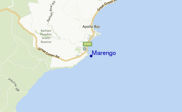
Marengo surf Forecast / VIC – Cape Otway / Australia
48hr Weather and Surf, issued 3 pm Tuesday 23 Apr 2024 AEST
Forecast update in hr min s Update imminent
Marengo surf forecast is for near shore open water. Breaking waves will often be smaller at less exposed spots.
Today's Marengo sea temperature is 17.1°C (Statistics for 23 Apr 1981-2005 - mean: 15.7 °C max: 17.2 °C min: 14.2 °C)
- Map Icons:
 Break
Break Live Wave Height (m)
 Live Wind Speed (km/h)
 Surf Rating (10 Max)
 Ocean Swells (m)
- Wind Speed (km/h)
Marengo surf forecast is for near shore open water. Breaking waves will often be smaller at less exposed spots.
Today's Marengo sea temperature is 17.1°C (Statistics for 23 Apr 1981-2005 - mean: 15.7 °C max: 17.2 °C min: 14.2 °C)
How big are the waves at Marengo today?
The current surf forecast for Marengo at 7PM is: 1.6m 17s primary swell from a Southwest direction and 1.4m 13s secondary swell from a Southwest direction (forecast issued at 03:00pm April 23). The wind direction is predicted to be offshore and the swell rating is 5.
| Time (AEST) & Date | Wave Height | Wave Period |
|---|---|---|
| Morning (23 Apr) | - | - |
| Afternoon (23 Apr) | 2.5ft (0.8m) | 18s |
| Evening (23 Apr) | 6ft (1.8m) | 16s |
Table - waves today at Marengo. (Swell directed towards the surf break)
Updates in hr min s Update imminent
Tuesday 23 | Wednesday 24 | Thursday 25 | Friday 26 | Saturday 27 | Sunday 28 | Monday 29 | Tuesday 30 | |||||||||||||||||||||||||||||||||||||||||||||||||||||
| 1 PM | 4 PM | 7 PM | 10 PM | 1 AM | 4 AM | 7 AM | 10 AM | 1 PM | 4 PM | 7 PM | 10 PM | 1 AM | 4 AM | 7 AM | 10 AM | 1 PM | 4 PM | 7 PM | 10 PM | 1 AM | 4 AM | 7 AM | 10 AM | 1 PM | 4 PM | 7 PM | 10 PM | 1 AM | 4 AM | 7 AM | 10 AM | 1 PM | 4 PM | 7 PM | 10 PM | 1 AM | 4 AM | 7 AM | 10 AM | 1 PM | 4 PM | 7 PM | 10 PM | 1 AM | 4 AM | 7 AM | 10 AM | 1 PM | 4 PM | 7 PM | 10 PM | 1 AM | 4 AM | 7 AM | 10 AM | 1 PM | 4 PM | 7 PM | 10 PM | |
Rating (10 max) | ||||||||||||||||||||||||||||||||||||||||||||||||||||||||||||
Swell Height Map |    |    |    |   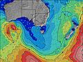 | 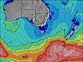 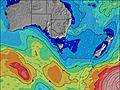 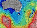 |    |  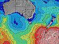 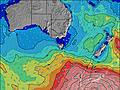 | 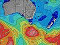 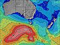  | ||||||||||||||||||||||||||||||||||||||||||||||||||||
| Wave Height (m) & direction (?) | ||||||||||||||||||||||||||||||||||||||||||||||||||||||||||||
| Period(s) (?) | 13 | 18 | 17 | 16 | 16 | 15 | 14 | 15 | 14 | 9 | 14 | 14 | 14 | 13 | 13 | 13 | 13 | 12 | 12 | 15 | 16 | 15 | 15 | 15 | 15 | 15 | 14 | 14 | 14 | 14 | 13 | 13 | 13 | 12 | 14 | 14 | 14 | 14 | 14 | 14 | 14 | 14 | 14 | 13 | 13 | 12 | 13 | 13 | 14 | 14 | 15 | 15 | 14 | 14 | 14 | 14 | 14 | 14 | 14 | 14 |
Wave (?)Graph | ||||||||||||||||||||||||||||||||||||||||||||||||||||||||||||
| Energy (?) | 335 | 528 | 1467 | 1707 | 1622 | 1246 | 5186 | 1198 | 4226 | 825 | 4479 | 4432 | 4181 | 2376 | 2354 | 2283 | 2107 | 1883 | 2908 | 2292 | 3326 | 3469 | 3247 | 3116 | 2830 | 2529 | 2061 | 1848 | 1534 | 1204 | 1018 | 1002 | 809 | 784 | 947 | 961 | 947 | 846 | 834 | 731 | 890 | 988 | 988 | 792 | 629 | 423 | 609 | 473 | 647 | 736 | 869 | 1279 | 1582 | 1700 | 1676 | 1676 | 1676 | 1676 | 1474 | 1291 |
Wind (km/h) | ||||||||||||||||||||||||||||||||||||||||||||||||||||||||||||
| Wind State (?) onshore cross-onshore cross-shore cross-offshore offshore glassy | cross- off | cross- off | off | cross- off | cross- off | cross- off | cross- off | cross- off | cross- off | cross- off | cross- off | off | cross- off | cross- off | cross- off | cross- off | cross- off | cross- off | cross- off | cross- off | cross- off | cross- off | cross- off | cross- off | cross- off | cross- off | cross- off | cross- off | glass | glass | cross- off | glass | cross | cross- off | glass | glass | cross- off | cross- off | cross- off | off | off | off | off | cross- off | cross- off | cross- off | cross- off | cross- off | cross- off | cross- off | cross | cross | cross | cross | cross | cross | cross | cross | cross | cross |
High Tide / height (m) | 12:33PM 1.70 | 1:17AM 2.16 | 1:00PM 1.74 | 1:46AM 2.30 | 1:26PM 1.76 | 2:15AM 2.40 | 1:51PM 1.76 | 2:44AM 2.44 | 2:16PM 1.76 | 3:15AM 2.43 | 2:41PM 1.74 | 3:47AM 2.37 | 3:07PM 1.70 | 4:22AM 2.26 | 3:37PM 1.65 | |||||||||||||||||||||||||||||||||||||||||||||
Low Tide / height (m) | 6:41PM 0.52 | 7:33AM 0.79 | 7:07PM 0.41 | 8:03AM 0.76 | 7:33PM 0.31 | 8:32AM 0.75 | 7:59PM 0.23 | 9:01AM 0.77 | 8:27PM 0.18 | 9:30AM 0.81 | 8:56PM 0.15 | 9:59AM 0.86 | 9:27PM 0.17 | 10:31AM 0.92 | ||||||||||||||||||||||||||||||||||||||||||||||
Tuesday 23 | Wednesday 24 | Thursday 25 | Friday 26 | Saturday 27 | Sunday 28 | Monday 29 | Tuesday 30 | |||||||||||||||||||||||||||||||||||||||||||||||||||||
| Sunrise | - | - | - | - | - | - | - | 7:01 | - | - | - | - | - | - | - | 7:01 | - | - | - | - | - | - | - | 7:03 | - | - | - | - | - | - | - | 7:03 | - | - | - | - | - | - | - | 7:05 | - | - | - | - | - | - | - | 7:05 | - | - | - | - | - | - | - | 7:07 | - | - | - | - |
| Sunset | - | 5:45 | - | - | - | - | - | - | - | 5:44 | - | - | - | - | - | - | - | 5:43 | - | - | - | - | - | - | - | 5:42 | - | - | - | - | - | - | - | 5:40 | - | - | - | - | - | - | - | 5:38 | - | - | - | - | - | - | - | 5:37 | - | - | - | - | - | - | - | 5:37 | - | - |
Rain (mm) | - | - | - | 4 | 6 | 2 | 1 | - | - | - | - | - | 1 | - | - | - | - | - | - | - | - | - | - | - | - | - | - | - | - | - | - | - | - | - | - | - | - | - | - | - | - | - | - | - | - | - | - | 2 | 1 | - | - | - | - | - | - | - | - | - | - | - |
| Temp. °C | 23 | 23 | 18 | 13 | 11 | 12 | 12 | 13 | 13 | 12 | 13 | 13 | 13 | 13 | 13 | 13 | 13 | 13 | 12 | 12 | 12 | 12 | 12 | 13 | 13 | 13 | 12 | 11 | 11 | 10 | 10 | 13 | 15 | 14 | 12 | 11 | 11 | 10 | 10 | 13 | 15 | 14 | 12 | 11 | 11 | 11 | 11 | 13 | 14 | 14 | 13 | 13 | 12 | 12 | 13 | 12 | 12 | 12 | 12 | 12 |
| Feels °C (?) | 18 | 21 | 16 | 7 | 5 | 5 | 4 | 6 | 6 | 6 | 8 | 8 | 9 | 7 | 8 | 8 | 8 | 8 | 7 | 8 | 8 | 9 | 9 | 10 | 10 | 10 | 9 | 9 | 10 | 8 | 8 | 11 | 13 | 12 | 11 | 10 | 9 | 8 | 8 | 11 | 12 | 11 | 10 | 8 | 8 | 8 | 8 | 11 | 10 | 10 | 9 | 8 | 7 | 7 | 8 | 7 | 7 | 7 | 7 | 8 |
FREE! Surf-Forecast.com widget for your website
The surf report / weather widget below is available to embed on third party websites free of charge and provides a summary of our Marengo surf forecast. Simply grab the html code snippet that we provide and paste it into your own site. You can choose your preferred language and metric/imperial units for the surf forecast feed to suit users of your site. Click here to get the code.


 Nearest